So this is my third trip to the Altai, and while I have driven through Koshagatch (and Kurai, where the Aktru Valley and Glacier are located) I have never had the amazing opportunity to go to really see it. Several years ago Karen Boldis brought a group of PSC students here and they did go. Lucky them! We need to get other PSC student over here ! It is amazing and amazingly beautiful.
We had a short weekend holiday from the University (Last Monday was a day off) and I convinced my colleague and host Natalia and her son Sergey to accompany the girls and I down to Koshagatch (about 6 hours south of Gorno). She has a really busy schedule and Sergey had some time off school, so we went. I really wanted to show my girls why this place is so special. Cities are cities and we have really enjoyed this one. But we are not City folk. My love of the Altai does not stem from being in Gorno. It comes from my experiences and memories of the incredible natural beauty and cool ecosystems, some of which I have written about.
The Koshagatch region is in the Steppe. How many chances do you get to go to the Steppe.. Sounds practically Mongolian!! In fact, we were about 100 km north of the Mongolian border when we stayed at Alec's place in Kurai.
First Stop Ongudai:
The scenery on the way down alone is worth the trip, as is the stop at Natalia's place in Ongudai Region. Both places we stayed had the Pethcka stove that warms the house through the walls of several rooms. My girls got their first taste of banya and I daresay they enjoyed it!

Petchka! heats 3 rooms!

Willa wakes in the morning at Natlias

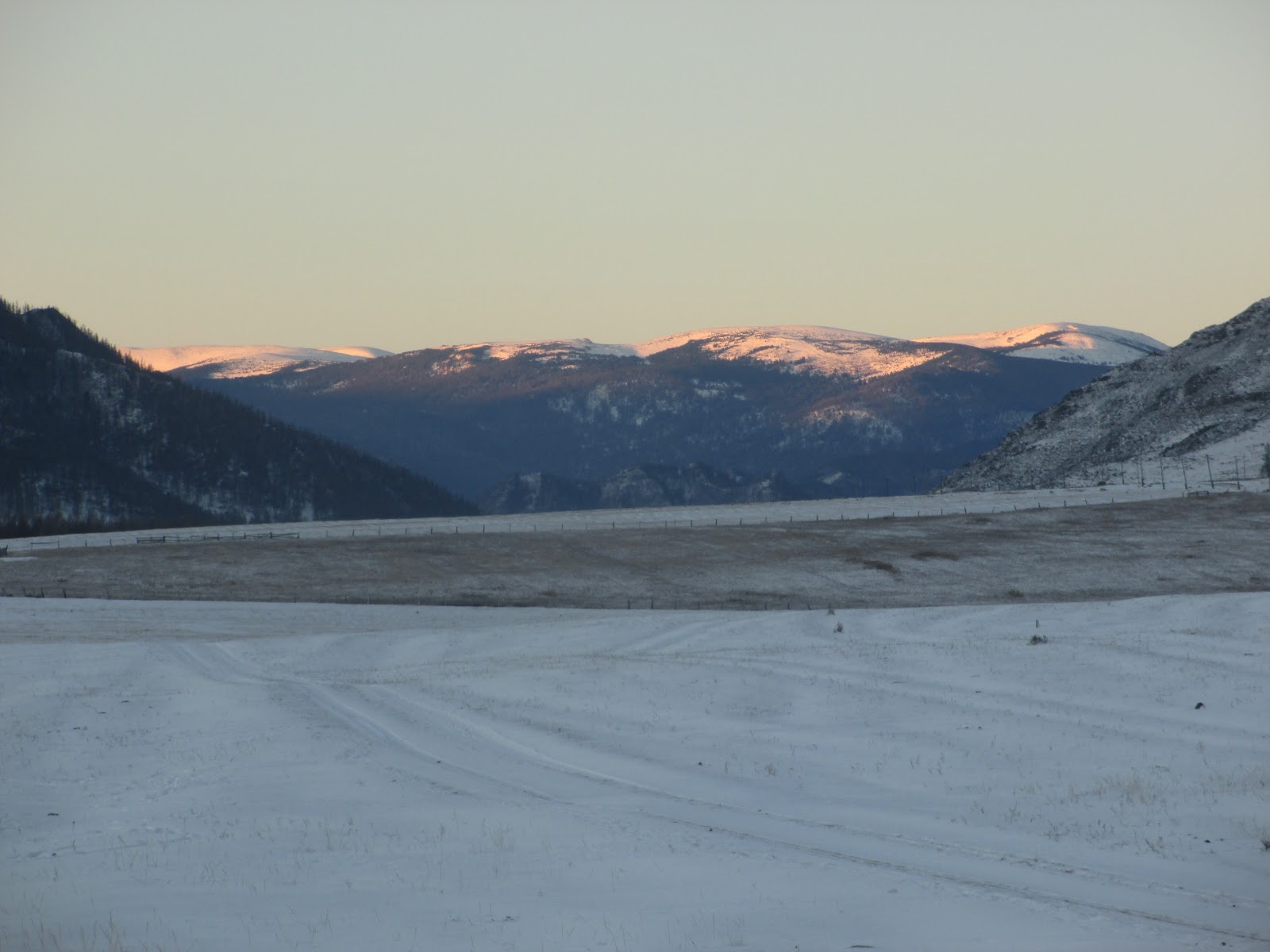
Morning in Ongudai

Sunrise on the neighboring mountains
With the fresh snow, the landscape is sort of stark and big, like the NA west.. You can see every line in each of the watersheds as you walk or drive along. Its a different perspective than we have in the Adirondacks.


 After spending the first night (Friday) with Natalia (there are many Natalias!!), we continued south and spend the day stopping at sacred places of the Altai people. These are springs, mountain passes, places where two rivers come together... and the mouths of valleys. Our first stop was at some large Kurgons (burial mounds) in the Karakol Valley, many which had been excavated. Kurgons were created in the permafrost so they tend to preserve bodies really well (well, as long as the permafrost lasts..)

Its pretty obvious in the landscape where Kurgons are located and which ones have been excavated by archaeologists.

 Natalia gave us some information about the Kurgons in the valley and the large stones that are near them. The meaning is not altogether clear, but the pattern of Kurgons is circles within circles on the landscape all around a beautiful sacred mountain peak called Oochen Mek (sp?). We are talking about large scale patterns on the landscape that are anthropogenic. One cannot take a picture of Oochen Mek because it is so sacred to the Altai people, but we were told that is you take a picture of something else and accidentally the mountain is in the picture, you have not offended the spirits of that place...... hmmm? I do respect the nature-based religion of the Altai people very much, so tried my best not to take a picture of this craggy 3 peaked mountain.
Moving on and Driving south:
I think the two coolest parts of an incredible 3 days and 3 nights were the petroglyphs in KalbakTash and the glacier itself.
The petroglyphs were discovered as workers built the highway (M52) and were blasting through rock. As you drive south along the M52 from Gorno, you are driving in the Valley of the Katun river for much of the way (Gorgeous, large Glacial river with the classic blue green water..) Other rivers join in as it makes it way from the headwaters of the Glaciers on Mt Belukha (to the east of the KoshAgach region where we went) north to where it discharges at Strotski in the north where the water is really big!


this is one such confluence, but not the one I talk about
where the petroglyphs are. This one is further north
but its so pretty I wanted to show it!
But I digress. The point is that the petroglyphs are located on an outcropping of rock (not unlike any other outcropping you might see along the way) that is near the confluence of two rivers. Whether that makes any difference or not as to why the rock art is located there is anybody's guess.
 But some hypotheses about why there is so much art in this one place - from the late Stone, Bronze, and Iron age - include the sacredness of river confluences; the thought that this may have been an important trade route or travel path for many peoples over time.... probably lots of other possible reasons that I dont know, but the petroglyphs are many and varied in what is depected and when they were created.
 The images, like the mountain goat above were done in the late Stone or Bronze age. The are made by using a pointed stone and another heavy object to bang small divets into the rock until the picture was created. This must have taken forever!!! The ages of the art span over a 1000 year period I believe.
To the left, here, is a great depiction of a deer with over emphasized antlers (this is common), and below it another ungulate with several somachs... or compartments in the body, also pretty common. I can remember what the researchers interpret this as...
The petroglyph below and to the left of the picture with Elsa, is a bit more difficult to see, but represents one from the Iron age where a sharp object (Iron?) is used to etch sharper lines in the rock.


 I havent had the opporunity to see petroglyphs in the states or anywhere in North America, and neither have my girls, so this represents a pretty big deal for us! I have been lucky to have been here twice before in my shorter visits, but sharing it with the girls was the best.


Note the compartments or holes in the stomach, again depicted in the animal to the left.
There are so many more... hunters, princesses and some things that are just anyones guess. We couldnt get great images of all of them.. You will just have to come and see for yourselves!!

Finally - Kosh Agach and Kurai Village
Our final destination in the Kosh Agach Region was the village of Kurai. As you drive south and get into this region and climb in elevation into this incredible steppe ecosystem, you are surrounded 360 by the mountains. The tallest mountain Belukha is to the east of us and I dont think you could see it from where we were, but I didnt ask... The mountain in this area were about 9,000 + feet and in the area of Altai snow leopard habitat as well.
 Elsa warms her toes after Ilya gets the petchka going to warm the house. Servey reclines on the table bench in the background. It can be really cold in KoshAgach, -60 below in the winter, but this weekend we had a relatively warm spell though the snow was still dry and fluffy.. gorgeous!
This is Ilya below. He was our driver. As a driver, one helps with the 'man' chores. These are, of course, things like chopping wood, getting the water for the banya from the pump in the yard, and making sure petchka is fired up and warm in the morning and throught the day. We were extra lucky, cause Ilya is a great guy and seems to enjoy cooking and playing cards with kids as much as he does chopping wood. He was great company, as many drivers are not.. He is quite atypical for a driver!


Dogs, like livestock, in the villages wander pretty freely, if they are friendly, and get into trash on a regular basis. They are pets to some degree, but more watch dog types with community ettiquette of their own. This one below with the girls was really sweet and submissive and he spent some time with us walking and visiting in the yard.
Driving up to the glacier on our second day in Kurai was a real trip. Its only 12 km but it takes over an hour on a good day. Two feet of fluffy snow on apparently non-existant roads across the steppe and through the woods as we climb toward the glacier in an Uazic ( 4 in back, three in front including the driver of the vehicle) did not really constitute good conditions. Our driver was an Altain man with incredible skills.
 At some point in the drive the chains had to go on to get us through deep snow through hilly, bumpy, almost tipping sideways, roads in the woods and across small rivers on the way to the base of the glacier. We laughed a lot as we braced for bumps and rose to almost hit the soft roof of the Uazic with our heads on several occasions. Pictures were quite difficult to get! Reminder: seatbelts in cities in Russia are something the driver puts on when the police are nearby. Most often you can't find them if you are in the back seat.. Now, cut to Siberia.. and Uazics (miliary issue Jeep/tank-like creatures!) and just laugh if someone asks about seatbelts!!!
 We took a bit of a break to wait for the 'safety Uazic' behind us... One car on a road like this might not be such a good idea, so we had a tag team going on.
We got to the houses at the base of the glacier, where the Mountain rescue teams stay (several people are injured or die a year climing these mountains and these glaciers, but this was a good year we are told.. no deaths!)
We started our walk up to as close as we can get to the glacier.
 This sign-post that we are surrounding in the left-hand picture has the names and relative directions of cities all over the world. Natalia says a long time ago there was one for the Adirondacks, but it is well covered up by now. We had some fun !
 This beautiful little structure is owned by one of the universities and may be a base camp for geological studies. From this point on you are above treeline.
We walked on .....


Ilya and me - as close as we came to
Aktru!
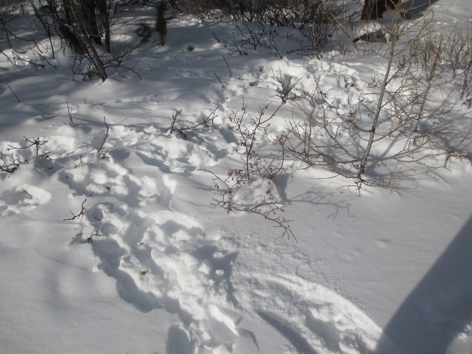
 One really fun thing for me on the way down was to stop and examine all the hare tracks and browse and pick up some pellets to bring home. This browse is about 7 or 8 millimeter diameter , which for hare is pretty big. It's a willow shrub based on the clasping buds. This was up pretty high on our walk after we left the rest of the group. Pretty exposed and really well browsed. It made me wonder if the population was high in these parts this year and if being that exposed (our of the conifers above treeline) was necessary to get what was needed to survive.
The browse in the photo below was more in the conifer belt on the way down the trail just as we hit treeline. There were many tracks and lots of places to hide down here. Browse was intense on the low growing shrubs

 As you can see, tracks were abundant and it was like old home week for me, watching where they went and what they were doing based on tracks, pellets and browse tips. The tracks seemed a similar size to our snowshoe hare in the Adirondacks. Maybe on the large side. Thought I didnt measure any exactly, an estimate of hind foot track length might be between 11 and 13 cm? Mountain Hare (Lepus timidus) I believe.

There was some drama on the way out after a lovely lunch standing around the warm hood of the Uazic in the sunny mountain afternoon.
A driver with a load of Mountain rescue squad people who had just been on the mountain for training, had started out before us. Their driver, clearly not as talented as ours chose the river instead of the road for part of the journey and by the time we came to the crossing, his back axel was up on a river rock so that the right rear tire was spinning in the air. We couldnt very well leave him them there.. so we played while Ilya and the driver moved rocks, hooked up a cable and generally pulled and directed the guy out of this jam.. maybe 40 - 45 minutes.
 These are the folks from the other Uazic watching from the sidelines and hoping.

Sergey and Willa walking out of the forest and back to the vehicles.
Below is a statue of a woman mountaineer that died climbing in these mountains. As I mentioned it is pretty common to have fatal accidents ...


We had a short weekend holiday from the University (Last Monday was a day off) and I convinced my colleague and host Natalia and her son Sergey to accompany the girls and I down to Koshagatch (about 6 hours south of Gorno). She has a really busy schedule and Sergey had some time off school, so we went. I really wanted to show my girls why this place is so special. Cities are cities and we have really enjoyed this one. But we are not City folk. My love of the Altai does not stem from being in Gorno. It comes from my experiences and memories of the incredible natural beauty and cool ecosystems, some of which I have written about.
The Koshagatch region is in the Steppe. How many chances do you get to go to the Steppe.. Sounds practically Mongolian!! In fact, we were about 100 km north of the Mongolian border when we stayed at Alec's place in Kurai.
First Stop Ongudai:
The scenery on the way down alone is worth the trip, as is the stop at Natalia's place in Ongudai Region. Both places we stayed had the Pethcka stove that warms the house through the walls of several rooms. My girls got their first taste of banya and I daresay they enjoyed it!

Petchka! heats 3 rooms!
 |
| Natlias cat enjoys a lot of mutton bones. Natlia has sheep and she eats the meat she raises like most Altaians that live in the villages. |

Willa wakes in the morning at Natlias

Morning in Ongudai

Sunrise on the neighboring mountains
With the fresh snow, the landscape is sort of stark and big, like the NA west.. You can see every line in each of the watersheds as you walk or drive along. Its a different perspective than we have in the Adirondacks.

 After spending the first night (Friday) with Natalia (there are many Natalias!!), we continued south and spend the day stopping at sacred places of the Altai people. These are springs, mountain passes, places where two rivers come together... and the mouths of valleys. Our first stop was at some large Kurgons (burial mounds) in the Karakol Valley, many which had been excavated. Kurgons were created in the permafrost so they tend to preserve bodies really well (well, as long as the permafrost lasts..)
Its pretty obvious in the landscape where Kurgons are located and which ones have been excavated by archaeologists.

The Kurgon in this image has been excavated, thats why the rocks are piled around the outside edges.
 Natalia gave us some information about the Kurgons in the valley and the large stones that are near them. The meaning is not altogether clear, but the pattern of Kurgons is circles within circles on the landscape all around a beautiful sacred mountain peak called Oochen Mek (sp?). We are talking about large scale patterns on the landscape that are anthropogenic. One cannot take a picture of Oochen Mek because it is so sacred to the Altai people, but we were told that is you take a picture of something else and accidentally the mountain is in the picture, you have not offended the spirits of that place...... hmmm? I do respect the nature-based religion of the Altai people very much, so tried my best not to take a picture of this craggy 3 peaked mountain.
Moving on and Driving south:
I think the two coolest parts of an incredible 3 days and 3 nights were the petroglyphs in KalbakTash and the glacier itself.
The petroglyphs were discovered as workers built the highway (M52) and were blasting through rock. As you drive south along the M52 from Gorno, you are driving in the Valley of the Katun river for much of the way (Gorgeous, large Glacial river with the classic blue green water..) Other rivers join in as it makes it way from the headwaters of the Glaciers on Mt Belukha (to the east of the KoshAgach region where we went) north to where it discharges at Strotski in the north where the water is really big!

this is one such confluence, but not the one I talk about
where the petroglyphs are. This one is further north
but its so pretty I wanted to show it!
But I digress. The point is that the petroglyphs are located on an outcropping of rock (not unlike any other outcropping you might see along the way) that is near the confluence of two rivers. Whether that makes any difference or not as to why the rock art is located there is anybody's guess.


To the left, here, is a great depiction of a deer with over emphasized antlers (this is common), and below it another ungulate with several somachs... or compartments in the body, also pretty common. I can remember what the researchers interpret this as...
The petroglyph below and to the left of the picture with Elsa, is a bit more difficult to see, but represents one from the Iron age where a sharp object (Iron?) is used to etch sharper lines in the rock.


Note the compartments or holes in the stomach, again depicted in the animal to the left.
There are so many more... hunters, princesses and some things that are just anyones guess. We couldnt get great images of all of them.. You will just have to come and see for yourselves!!

Finally - Kosh Agach and Kurai Village
Our final destination in the Kosh Agach Region was the village of Kurai. As you drive south and get into this region and climb in elevation into this incredible steppe ecosystem, you are surrounded 360 by the mountains. The tallest mountain Belukha is to the east of us and I dont think you could see it from where we were, but I didnt ask... The mountain in this area were about 9,000 + feet and in the area of Altai snow leopard habitat as well.

This is Ilya below. He was our driver. As a driver, one helps with the 'man' chores. These are, of course, things like chopping wood, getting the water for the banya from the pump in the yard, and making sure petchka is fired up and warm in the morning and throught the day. We were extra lucky, cause Ilya is a great guy and seems to enjoy cooking and playing cards with kids as much as he does chopping wood. He was great company, as many drivers are not.. He is quite atypical for a driver!


Dogs, like livestock, in the villages wander pretty freely, if they are friendly, and get into trash on a regular basis. They are pets to some degree, but more watch dog types with community ettiquette of their own. This one below with the girls was really sweet and submissive and he spent some time with us walking and visiting in the yard.

Driving up to the glacier on our second day in Kurai was a real trip. Its only 12 km but it takes over an hour on a good day. Two feet of fluffy snow on apparently non-existant roads across the steppe and through the woods as we climb toward the glacier in an Uazic ( 4 in back, three in front including the driver of the vehicle) did not really constitute good conditions. Our driver was an Altain man with incredible skills.


We got to the houses at the base of the glacier, where the Mountain rescue teams stay (several people are injured or die a year climing these mountains and these glaciers, but this was a good year we are told.. no deaths!)

We started our walk up to as close as we can get to the glacier.


We walked on .....

This is where most of us turned around. Elsa, Willa and I had bad footwear for traction and cold (though it wasnt too cold this day!). Elsa and Willa turned around here with Natalia. Sergei, Ilya and I, continued on a-ways for a bit closer view. You can see the Aktru glacier in the background. On our right you can see that the ridge falls off there. That is where the glacier used to be, only as far back as 2004. Now it is all the way up the valley behind where we are standing! Warming here has been severe like in the Adirondacks in winter and a huge melt of glaciers is occuring.

Ilya and me - as close as we came to
Aktru!


The browse in the photo below was more in the conifer belt on the way down the trail just as we hit treeline. There were many tracks and lots of places to hide down here. Browse was intense on the low growing shrubs

 As you can see, tracks were abundant and it was like old home week for me, watching where they went and what they were doing based on tracks, pellets and browse tips. The tracks seemed a similar size to our snowshoe hare in the Adirondacks. Maybe on the large side. Thought I didnt measure any exactly, an estimate of hind foot track length might be between 11 and 13 cm? Mountain Hare (Lepus timidus) I believe.
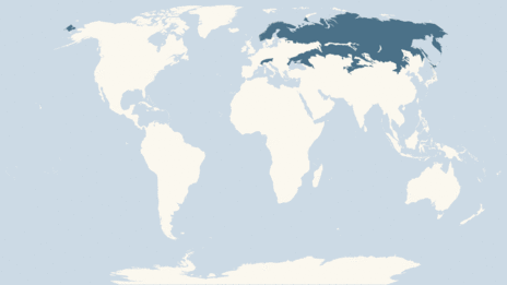
This is the mountain hare distribution map - I feel so lucky! http://www.bbc.co.uk/nature/life/Mountain_Hare

There was some drama on the way out after a lovely lunch standing around the warm hood of the Uazic in the sunny mountain afternoon.
A driver with a load of Mountain rescue squad people who had just been on the mountain for training, had started out before us. Their driver, clearly not as talented as ours chose the river instead of the road for part of the journey and by the time we came to the crossing, his back axel was up on a river rock so that the right rear tire was spinning in the air. We couldnt very well leave him them there.. so we played while Ilya and the driver moved rocks, hooked up a cable and generally pulled and directed the guy out of this jam.. maybe 40 - 45 minutes.

Sergey and Willa walking out of the forest and back to the vehicles.
Below is a statue of a woman mountaineer that died climbing in these mountains. As I mentioned it is pretty common to have fatal accidents ...


As we had a lunch on the hood of the Uazik in the gorgeous warm early winter sun, we had to take pictures of this guy above. This really cute dog was living at the base houses with the mountain rescue guys.. We were smitten with his need to bring you a piece of wood and wait until you would throw it, over and over again. If the toss wasn't perfect the pup would just reposition himself, and wait for you to get the poorly tossed piece of wood - poised in this position. We took this picture specifically for our friends John and Becky who have and love border collies:-)

One more good tired night at Alecs place in Ongudai, a lot of card games and other things, then off back north on Monday - 6 hours straight to Gorno. We had a little bit of heaven this weekend. We won't soon forget it.
Incredible...
ReplyDelete